Stay in touch with NIHO!


| Listing Number: | OM27 |
|---|---|
| Size: | 30.6 Acres |
| Price: | SOLD |
| Legal: | Fractional SW 1/4 North of River, District Lot 1413, except Plan 1857, Cassiar District. PID: 009-750-894
|
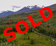
| Description: | There is approximately 1,650 feet of frontage on the Kitwanga River. A small and very clear spring, is located approximately 100 feet behind the remains of an old cabin. The Kitwanga valley and this very scenic property is surrounded by the snow capped peaks of the Hazelton Mountain Range. The topography of the land is mainly flat along the river and rises as you move towards the north boundary. There are remains of an old hand hewn log cabin overlooking the river located near the east boundary of the property. |
| Location: | Approximately one mile northwest of the Village of Kitwanga; approximately 60 miles (96 kilometres) west of Smithers and 60 miles (96 kilometres) east of Terrace. |
| Access: | Access is by foot or by the river. There is no road access to the property. Regional airports in both Smithers and Terrace offer domestic flights to Vancouver, Calgary, Kelowna, Prince George and Dease Lake. The village is on both Via Rail and CNR’s mainlines. |
| Recreation: | The Kitwanga River is a small, clear river well known for its excellent stocks of Salmon, Trout and Dolly Varden Char. As it is a regulated Class II River year round, check the Provincial Fishing Regulations before setting out. Kitwanga is well known for their hiking, biking and cross country skiing trail system, many of which have spectacular views of the jagged peaks of the Mountain Massif, called “Seven Sisters”. In the winter, snowmobiling becomes very popular among many of these same trails. Kitwanga Mountain Provincial Park was established in 1997, encompassing 720 hectares. North of Cedarvale, the mountains are in the Nass Range near Kitwanga. The trail was rebuilt through a joint project by BC Parks and volunteers from Round Square International Schools at Soaring Spirits Camp. This area is home to wildlife of all sorts, including bears, mountain goats, coyotes, wolves , and more. Many moose and mule deer have been seen on the property. |
| Services: | None |
| Area Data: | The Village of Kitwanga, also known as Gitwangak ,is at the junction of the Yellowhead Highway and Highway 37 and is the Gateway to the North. From here you can take the Stewart Cassiar Highway and travel to the Yukon and Alaska. Kitwanga has general services including gas, groceries, restaurants, post office, and elementary school. The 1893 St Paul’s Anglican Church and Bell Tower at Kitwanga are landmarks that cannot be missed. The different Clan totem poles that line the river can be viewed and are easily accessible. Full services including hospital and commercial air service are available in the City of Terrace located 60 miles to the west. Most of the surrounding area is small farms and small cattle ranches. |
| History: | Kitwanga or Gitawangak is a term meaning “people of the place of rabbits”. Today, the Gitwangak history and culture is commemorated at the Gitwangak Battle Hill National Historic Site. This is the site of a Gitwangak victory where the warrior Nekt held his attackers at bay, by rolling logs down the hill to crush them. Research indicates that this was a fortified encampment used by native peoples to maintain a stronghold on fishing and trade routes. The surrounding area is rich in First Nations history, and is home to over 50 totem poles. Nearby Hazelton is home to the ‘Ksan Indian Village Museum which also include Gitksan artifacts and buildings. In the early days of British Columbia, Kitwanga would be the refueling point for steamboats on the Skeena River before continuing upriver to Hazelton. When the Grand Trunk Pacific Railway began to further open up BC’s North, many railworkers from the surrounding rural areas settled in Kitwanga. In the 1950’s the forestry boom brought more settlers, as families moved in to take advantage of the logging and milling jobs at the (still operating) Kitwanga Forest Products mill. |
| Vegetation: | The property is fully covered with Aspen, Cottonwood, and Birch trees throughout and some scattered Spruce. |
| Boundaries: | The boundaries were surveyed by J.M. Mulligan, British Columbia Land Surveyor, July 1991. |
| Taxes: | $306.61 (2018) |
| Zoning: | Rural residential and open space designation in Kitwanga official settlement plan. |
| Sold Date: | 2019 |